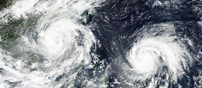
A string of unusually powerful typhoons has torn through East Asia's coastlines for months, killing dozens, shuttering major airports and wiping out crops across the Philippines, Taiwan, China and Japan, as an intensifying El Niño pattern pumps extra energy into the Pacific's storm season.
In October, nearly all of Taiwan shut down as Typhoon Champi, packing winds equivalent to a category five hurricane at 295 km/h (183 mph), bore down on the island's northeastern coast. It ultimately skirted Taiwan without making landfall, but still canceled hundreds of flights across Hong Kong, Taiwan and Japan, cut power to 15,000 homes in Okinawa and sent waves crashing over seaside highways in the Philippines' Batanes islands. In June, two storms — Typhoon Mekkhala and Severe Tropical Storm Higos — raced toward Japan's eastern coast simultaneously, forcing a million people to evacuate. July's Tropical Storm Narra submerged villages along China's Guangxi coast, and August's Super Typhoon Dolphin churned across the Pacific for 16 days before triggering heavy floods and dozens of casualties in eastern China.
A Pacific 'Burning With Fever'
According to the Accumulated Cyclone Energy index, which measures the combined intensity of a season's storms, this year's reading for East and Southeast Asia is tracking at nearly double the 30-year average. El Niño — a naturally recurring climate pattern in which warm water pools in the eastern Pacific and shifts global wind patterns — is forecast by the UK Met Office to be the strongest in living memory, with effects expected to persist into February or March.
It can go into convulsions soon.
Ana Liza Solis, head of climatology, Philippine national weather bureau, describing the Pacific Ocean's record-high temperatures
Forecasters say El Niño is also pushing typhoons to form farther east than usual, giving them more time over warm water to intensify before reaching land. Sea surface temperatures in the equatorial Pacific rose again last month, according to monitoring cited by the Japan Meteorological Agency, suggesting the pattern has not yet peaked.
For coastal communities across the region, the toll has gone beyond the storms themselves: disrupted shipping and air travel, damaged rice and vegetable crops, and repeated evacuations have strained local governments still recovering from the previous system. Scientists caution that no single storm can be attributed directly to climate change, but note that warmer ocean surface temperatures — linked to both El Niño and longer-term warming trends — are a well-established driver of more intense tropical cyclones, and that satellite monitoring from NASA's Earth Observatory is increasingly used to track the trend in real time.